|
Hello, I noticed that i have the option to insert a file attribute for use to upload files or photos when i design a survey in the format of Collect Desktop . But this option is missing when i try to build one Collect Earth survey? Is it possible insert one files or photos in Collect Earth? Sometimes some photos are available for the plot under investigation? Thanks, Jinkai |
|
Hi Jinkai, Thank you for the suggestion, we will try to include this option on the coming versions of Collect Earth. /Alfonso |
|
Hello, Has the option to include photos been made possible for the latest collect earth version? I am looking to add high resolution images (30m x 30m) for interpreters to validate. Hopefully it is possible. Thanks |
|
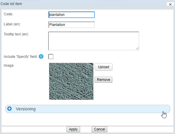
Hi, We have the option to include images that appear as tooltips when the user puts the mouse over the codelist option. This only works when the code item is using the "Textbox" option. When you edit a code item you can add the image (with the limitation of it being under 300KB)
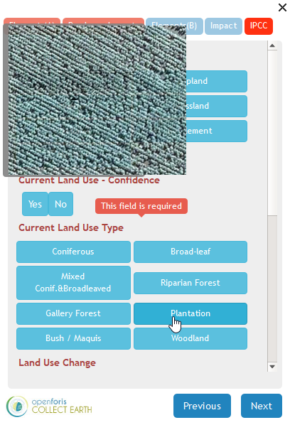
Then in the Collect Earth balloon in Google Earth it appears like this (ATTENTION: there is a problem in the preview in the Survey Designer and the image is not shown properly there, only when you open the balloon inside Google Earth)
Maybe this is not the best way to show the possible representations of the different classes, so it might be better if you develop some sort of "Visual Interpretation Guidelines" document for your project that the interpreters can follow. |
|
Thanks for this - very useful We were hoping to incorporate high resolution images from digital globe for points where the imagery isn't available in google earth. The idea being that the users can validate the change based on these images. It would be great to embed them, but doesn't sound like this is possible. |
|
Ok, so I missunderstood the question. You have two options then: Build a KML file that links those images so that it can be opened in Google Earth (this would require to distribute the images to the interpreters), if these are GeoTiffs they can be opened directly inside Google Earth Pro! OR use some a WMS server to serve the imagery and also link that through a KML. Here are two examples of that : KML With an ImageOverlay of Ortophotos from the Italian Ministry of the Environment and the KML With the an ImageOverlay of Ortophotos from the Spanish Ministry of Agriculture It is possible that Digital Globe offers some sort of service to serve the imagery. |