Dear Openforis team:

I would like to import the test_plots.ced file included in the drylands_demo example to collect and then modify it to create my own survey. However, when I try to do that an error displays:

"File type not supported. Only valid Collect Backup ZIP files can be imported".

I have used collect earth to export the zipped xml file but it doesn't work, am I doing the right thing?.

Thank you very much

Regards,

Pablo

asked 27 Jan '16, 11:35

pablo_martin's gravatar image

pablo_martin
11123
accept rate: 0%


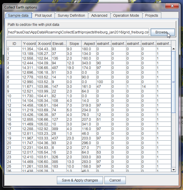
Hi Pablo,

I think that the problem is that you are trying to import the list of plots the wrong way.

In order to change the set of plots loaded by Collect Earth and visualized through Google Earth what you need to do is to go to Tools->Properties. There in the first tab (the "Sample data" tab) you need to click on the browse button to load the CSV file:

alt text

Hope this helped!

permanent link

answered 27 Jan '16, 12:22

collectearth's gravatar image

collectearth ♦
1.0k16
accept rate: 17%

Dear team:

My question was related with "collect", the web tool to create surveys. I wanted to use the example provided that comes with Collect Earth (drylands monitoring) import it to collect and then modify the survey adding or deleting the tabs or fileds adapting it to my requirements.

Finally, I created a new survey by choosing the "Open Foris Collect earth + IPCC" example and using a grid in .csv I think that would be fine by now.

Thank you very much for your answer anyway

Regards,

Pablo

permanent link

answered 27 Jan '16, 12:48

pablo_martin's gravatar image

pablo_martin
11123
accept rate: 0%

Hi Pablo,
Unfortunately nowadays you cannot import a .cep file (the Collect Earth Project file) into Collect, but we are working on such a feature.
Meanwhile you can import the survey definition file (placemark.idm.xml) that is inside the .cep file in the Survey Designer. That file contains all the structure of the survey (the attributes defined in the Schema section). You can then modify the structure of the survey and export it again with the Collect Earth format (don't forget to add to the generated file other files like area_per_attribute.csv and so on).
Thanks a lot,
Open Foris Team

permanent link

answered 29 Jan '16, 10:03

Stefano%20%28OF%29's gravatar image

Stefano (OF) ♦♦
4.7k19
accept rate: 20%

Your answer
toggle preview

Follow this question

By Email:

Once you sign in you will be able to subscribe for any updates here

By RSS:

Answers

Answers and Comments

Markdown Basics

  • *italic* or _italic_
  • **bold** or __bold__
  • link:[text](http://url.com/ "title")
  • image?![alt text](/path/img.jpg "title")
  • numbered list: 1. Foo 2. Bar
  • to add a line break simply add two spaces to where you would like the new line to be.
  • basic HTML tags are also supported

Question tags:

×493

question asked: 27 Jan '16, 11:35

question was seen: 7,627 times

last updated: 29 Jan '16, 10:03