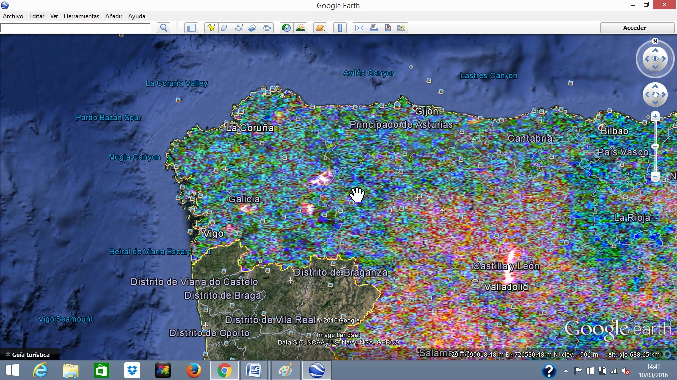
I am trying to add Very High Resolution Imagery from the Spanish ortophoto project PNOA to Google Earth.

This is the link to the PNOA Web Mapping Service WMS=http://www.ign.es/wms-inspire/pnoa-ma?Request=GetCapabilities&Service=WMS

I've tried and the result is the attached file. Thank you alt text

asked 10 Mar '16, 14:48

JorgeCast's gravatar image

JorgeCast
21124
accept rate: 0%

edited 13 Mar '16, 11:22

Open%20Foris's gravatar image

Open Foris ♦♦
9995714


Dear Jorge,

In order to add a WMS service carrying Very High Resolution imagery to the Google Earth interfaceyou need to add an image overlay to Google Earth and set the "Refresh" parameters adding the WMS URL.

This is a good explanation on how to do it: Adding a WMS linkto Google Earth

Once you have an image-overlay working you can actually save it as KML or KMZ from Google Earth.

  • This is an example of the PNOA imagery (You need to zoom into Spain) : LINK ( It uses a different URL so I am not sure if it is the same one you are refering to : http://www.idee.es/wms/PNOA/PNOA?VERSION=1.1.1)
  • This is from the USGS ortophoto archive (only in the US): LINK

Sometimes WMS servers can beery slow so take that into account...

permanent link

answered 13 Mar '16, 12:26

Open%20Foris's gravatar image

Open Foris ♦♦
9995714
accept rate: 10%

edited 13 Mar '16, 12:29

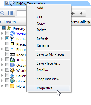
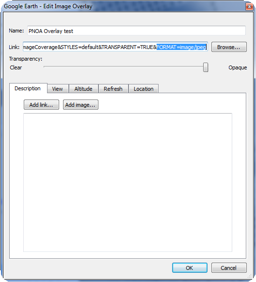
I have bee reviewing the original question and it seems that the problem when adding the original WMS service was due to the FORMAT and the WIDTH and HEIGHT that is set automatically by Google Earth when adding the image overlay!

So it seems that Google Earth automatically chooses the image/gif format to fetch the WMS imagery. This shows strange colors on the image!!

If you change the FORMAT to image/jpeg ( by right clicking on the image overlay icon on the left frame and choosing Properties ) on the description of the image overlay then the colors go back to normal and you see the ortophoto with the original colors. It seems however that the imagery from Google Earth is better than that from PNOA.

Finally in order to get a better resolution of the imagery you also need to change the WIDTH and HEIGHT parameters to 4096. The WIDTH and HEIGHT parameters for other WMS services might be different. For instance 2048x2048 or 1024x1024.

alt text

alt text

These are examples of URLs that work well:

SPAIN PNOA ( MORE INFO AND HERE):

http://www.ign.es/wms-inspire/pnoa-ma?SERVICE=WMS&VERSION=1.1.1&REQUEST=GetMap&SRS=EPSG:4326&WIDTH=1024&HEIGHT=1024&LAYERS=OI.OrthoimageCoverage&STYLES=default&TRANSPARENT=TRUE&FORMAT=image/jpeg

http://www.idee.es/wms/PNOA/PNOA?SERVICE=WMS&VERSION=1.1.1&REQUEST=GetMap&SRS=EPSG:4326&WIDTH=4096&HEIGHT=4096&LAYERS=PNOA&STYLES=default&TRANSPARENT=TRUE&FORMAT=image/jpeg

ITALIAN ORTOFOTOS 2000 (MORE INFO GEOPORTALE NAZIONALE):

http://wms.pcn.minambiente.it/ogc?map=/ms_ogc/WMS_v1.3/raster/ortofoto_colore_00.map&VERSION=1.1.1&REQUEST=GetMap&SRS=EPSG:4326&WIDTH=2048&HEIGHT=2048&LAYERS=OI.ORTOIMMAGINI.2000.&STYLES=default&TRANSPARENT=TRUE&FORMAT=image/jpeg

GUATEMALA SINIT ORTOPHOTOS 2006 ( MORE INFO ):

http://ide.segeplan.gob.gt/cgi-bin/mapserv.exe?map=/ot_web/ot_overview_1.map&SERVICE=WMS&VERSION=1.1.1&REQUEST=GetMap&SRS=EPSG:4326&WIDTH=2048&HEIGHT=2048&LAYERS=map_generated_by_gvsig&STYLES=default&TRANSPARENT=TRUE&FORMAT=image/jpeg&

COSTA RICA ( MORE INFO SNIT SERVICE ):

http://geos0.snitcr.go.cr/cgi-bin/web?map=ortofoto.map&VERSION=1.1.1&REQUEST=GetMap&SRS=EPSG:4326&WIDTH=2048&HEIGHT=2048&LAYERS=ORTOFOTO&STYLES=default&TRANSPARENT=TRUE&FORMAT=image/jpeg&

URUGUAY ( FROM THE IDEuy GEOPORTAL )

Here it is important to note that the SRS must be set to EPSG:4326 as this is the system used by Google Earth to define the bounding box of the view! In the Uruguayan geoportal they use their national coordinate system instead:

https://mapas.ide.uy/geoserver-raster/ortofotos/wms?SERVICE=WMS&VERSION=1.1.1&REQUEST=GetMap&FORMAT=image/jpeg&TRANSPARENT=true&LAYERS=ortofotos:ortofoto_infrarroja_nacional&WIDTH=1024&HEIGHT=1024&SRS=EPSG:4326

https://mapas.ide.uy/geoserver-raster/ortofotos/wms?SERVICE=WMS&VERSION=1.1.1&REQUEST=GetMap&FORMAT=image/jpeg&TRANSPARENT=true&LAYERS=ortofotos:ortofoto_nacional&WIDTH=1024&HEIGHT=1024&SRS=EPSG:4326

KML File with the 2017-2018 natural and infra-red layers

GUATEMALA( FROM THE IDEG GEOPORTAL )

The WMS URL used is this one :

https://ideg.segeplan.gob.gt/geoserver/wms?service=wms&SERVICE=WMS&VERSION=1.3.0&REQUEST=GetMap&FORMAT=image/png&TRANSPARENT=true&LAYERS=ortofotos-imagenes:ORT&WIDTH=2048&HEIGHT=2048

KMZ File with the 2016 Ortophotos of Guatemala

permanent link

answered 01 Nov '16, 11:10

collectearth's gravatar image

collectearth ♦
1.0k16
accept rate: 17%

edited 20 Jan '23, 15:44

Open%20Foris's gravatar image

Open Foris ♦♦
9995714

Your answer
toggle preview

Follow this question

By Email:

Once you sign in you will be able to subscribe for any updates here

By RSS:

Answers

Answers and Comments

Markdown Basics

  • *italic* or _italic_
  • **bold** or __bold__
  • link:[text](http://url.com/ "title")
  • image?![alt text](/path/img.jpg "title")
  • numbered list: 1. Foo 2. Bar
  • to add a line break simply add two spaces to where you would like the new line to be.
  • basic HTML tags are also supported

Question tags:

×281

question asked: 10 Mar '16, 14:48

question was seen: 23,459 times

last updated: 22 Jan '23, 13:53