Case Studies
Greenhouse gas reporting is about to get a whole lot easier – 2022
FAO’s development of new features in Collect Earth means country land use data will be more easily accessed and interpreted through the IPCC’s Greenhouse gas Inventory software.
The Food and Agriculture Organization (FAO) of the United Nations is working to ensure that reporting to the United Nations Framework Convention on Climate Change (UNFCCC) on Greenhouse gas (GHG) emissions will be simpler and more accurate.
Through this recently approved project, FAO is working with the IPCC Task Force on National Greenhouse Gas Inventories connecting Collect Earth, a free and open-source, satellite image viewing and interpretation system with the Intergovernmental Panel on Climate Change (IPCC) Inventory Software, giving all countries that are signatories to the UNFCCC the opportunity to enhance their Greenhouse Gas inventories (GHGi) with more accurate data on emissions in the agriculture, forestry and other land use sectors.
The Agreement
The project is the result of a United Nations to United Nations Contribution Agreement signed between FAO and the IPCC/ World Meteorological Organization (WMO).
The development of the tool demonstrates how working together between United Nations organizations can ensure no one is left behind “This opportunity is not just about technological developments” said FAO Director of the Office of Climate Change, Biodiversity and Environment, Eduardo Mansur “it’s about giving more countries the chance to produce accurate Greenhouse gas inventories on agriculture, forestry and other land use.”
Countries often report difficulties in preparing their inventories, and Least Developed Countries in particular face a number of constraints in the quantity and quality of data required, many lack data management systems so are unable to prepare a complete and accurate GHG inventory.
The current IPCC Inventory Software can make simple estimations, based on generalized emission factors for all sectors, known as Tier 1 but countries soon come up against a barrier – the lack of country-specific data on land types and land use. This new version of the IPCC software that is being developed will integrate the accurate Land Use Change data generated by Collect Earth, enabling countries to compile and report on their national GHG data at Tier 2 – Tier 3 levels. Tier 2 standards need locally specific data and Tier 3 require very detailed data on actual land areas, for example deforestation for agricultural land or settlements.
“Bridging the void between existing software that thanks to Google technologies already provides instant access to both very high spatial and very high temporal resolution data within a simple framework will enable countries to compile the greenhouse gas inventories without costly computer systems or specialist skills” says Danilo Mollicone, lead technical officer of the FAO’s technical team that created Collect Earth and is developing the new software.
Users of the new software will need minimum guidance and expertise to use it, many have already benefited from other FAO-Google tools. This tool will offer something more, integration with the current IPCC software to use the sample data on land use and land cover through analysis of remotely sensed images. The new software supports the preparation of highly accurate GHG inventories. It allows users to analyse and export land data that can then be uploaded in the IPCC inventory software.
Country involvement
Collect Earth is one such tool that makes it possible for countries to measure and report accurate and transparent emissions and removals estimates. Such estimates are transparent as (a) the entire data collection process (from design to analysis) can be independently reviewed and reproduced, (b) the use of a systematic sampling design is more transparent and statistically robust compared to using randomly allocated plots, and (c) that data itself can be used to produce related statistical uncertainties. At the time of writing, thirty-five countries have used Collect Earth to develop their REDD+ Forest Reference Emissions Level or Forest Reference Level (FREL/FRL) submitted to the UNFCCC REDD+ Web Platform.
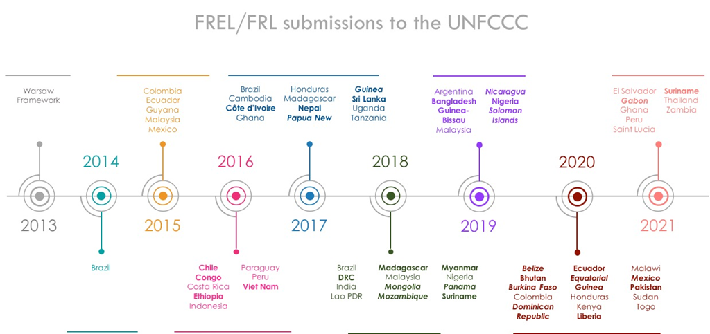
FREL/FRL submissions to the UNFCCC. Countries in bold italic use Collect Earth to collect Activity Data information, while countries in bold used Collect Earth to evaluate map accuracy.
Edgar Correa, leading the Geospatial Monitoring Unit of the Belize Forest Department (GSMU – FD) described how Belize already uses Collect Earth in their UNFCCC communications and will be piloting the compilation of the GHG inventory using the new tool.
In the next two-three years it is expected that UNFCCC signatory countries will adopt the new IPCC GHG software. This level of reporting will help financial mechanisms under the UNFCCC as data reported within the national GHG inventories is used to report countries’ emissions and removals.
Land Use and Land Cover Assessment through Augmented Visual Interpretation- 2016
Collect Earth, developed by the Food and Agriculture Organization of the United Nations (FAO) with the expertise of Google Earth and Earth Engine enables countries to assess and monitor forest cover, facilitating teir reporting of greenhouse gas emissions to the United Nations Framework Convention on Climate Change (UNFCCC) in the context of the United Nations Collaborative Programme on Reducing Emissions from Deforestation and Forest Degradation in developing countries (REDD+).
Funding from the environmental arm of the German government, the International Climate Initiative (IKI), has enabled FAO to provide training and technical support to governments in the use of Collect Earth, revolutionizing their ability to monitor land use and desertification.
More than 30 countries are now using Collect Earth to manage and assess land use and land use change. In one example, the Forest Authority of Papua New Guinea, one of the world’s largest reservoirs of biodiversity, completed its first full assessment of land use, land use changes and forests in support of its first ever National Forest Inventory. “Collect Earth enabled us to significantly improve our understanding of forest and land use in Papua New Guinea and their changes over time. Reliable information is essential for good planning and sustainable management of forest, a vital source of livelihood for the majority of our nation’s population.” said Goodwill Amos, Acting Managing Director of Papua New Guinea Forest Authority.
In Tunisia and Kyrgyzstan, national forest authorities used Collect Earth to collect accurate inventories of forest cover in order to combat desertification. Satellite images that used to take days to download and years of expertise to process can now be analyzed and visualized in a fraction of that time. Collect Earth provides instant access to both very high spatial and very high temporal resolution data within a simple framework built upon Google technologies. Its simple interface and flexibility allow even non-experts to use it.
The U.S. Department of the Interior is using Collect Earth to strengthen developing country partners’ collection methods to monitor land cover changes and control forest cover for climate mitigation and adaptation. As noted by Jean Parcher, former Project Manager for Department of the Interior’s International Technical Assistance Program’s Land Cover for Climate Initiative (LC4Climate), “the synergy between the Collect Earth team and the LC4Climate land cover and remote sensing trainers has provided rapid capacity development opportunities in Africa and South East Asia to develop National Carbon Emission Inventories. The Collect Earth package provided easy access to multi-temporal and high-resolution satellite imagery along with innovative tools for rapidly sampling changes to land use and land cover over time.”
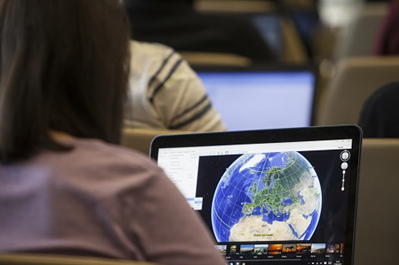
11 April 2016, Rome, Italy – Training – Google mapping and Google Earth training sessions. FAO Headquarters (Sheik Zayed Media Center).
Collect Earth has also played an important role in the initial stages of the Global Forest Survey, a global web-based platform which will enable the sharing and collection of world forest data. As a first phase of the project, FAO, working with worldwide partners including governments, universities, research institutes and NGOs, recently conducted the first global assessment of forests and trees in the drylands at a regional level.
In an exercise that previously would have taken years but which was completed in seven months, Collect Earth made it possible to collect data from more than 200,000 sample plots around the dry regions of the world, covering 45% of the world’s terrestrial lands with a systematic sampling design. More than 70 parameters were recorded on each plot, from land-use assessment to the detailed counting of small objects such as trees and shrubs, providing an unprecedented level of information. The assessment, which will go global, has revealed that the world’s drylands host much more forest and woodland than originally estimated, covering 18 percent of the drylands area.
“Within the space of just one year, Collect Earth has filled a major gap in our knowledge of the distribution of the world’s forests, and given governments, especially those with large areas of drylands, a major new tool to report on their progress in REDD+, achieving Land Degradation Neutrality, and combating desertification. FAO deserves every congratulation for this huge achievement,” said Dr Alan Grainger, of the School of Geography at the University of Leeds.
Collect Earth offers a breakthrough in helping governments to assess land use and land use change, and in their planning of ways to mitigate greenhouse gas emissions. Thanks to the worldwide use of open data policies, the international community now has a new tool way to improve its knowledge and understanding of forests, biodiversity, and the use of forest resources and the effects of climate change on natural resources.