
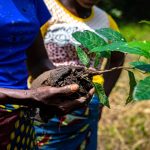
Strengthening regional capacity for restoration monitoring under GBF Target 2
February 17, 2026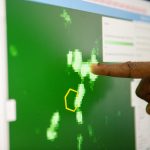
The digital revolution in forest monitoring: From Foris to Open Foris
March 6, 2026Open Foris is a free, open-source initiative of forest and land monitoring solutions developed by FAO. The portfolio makes environmental monitoring more accessible, transparent, and collaborative for governments, communities, researchers, and practitioners worldwide.
From collecting data in the field to analysing satellite imagery and supporting national reporting, Open Foris enables data-driven decisions for climate action, sustainable land use, ecosystem restoration, and environmental transparency.
“Open Foris is built on the belief that transparent, accessible and open-source data can accelerate climate action. By combining innovation with inclusiveness, Open Foris solutions ensure that every country, regardless of resources, can harness the power of free data for climate and forest monitoring,” said Julian Fox, FAO’s Forest Monitoring Team Leader.
Five focus areas, one integrated portfolio
To meet diverse user needs — from local communities to national forest monitoring systems — Open Foris solutions are organized into five functional areas:
- Field data collection – capturing georeferenced forest, environmental and socio-economic data
- Visual interpretation – interpreting satellite imagery for land-cover and land-use assessment
- Data management – designing surveys, managing inventories and ensuring data quality
- Geospatial analysis – cloud-based satellite data access, processing and reporting
- Integrated solutions and risk assessment – combining datasets for restoration tracking and deforestation risk assessment
Together, these solutions function as interoperable building blocks rather than standalone tools. Here is a summary of the ten solutions from Open Foris:
Field data collection
Arena Mobile
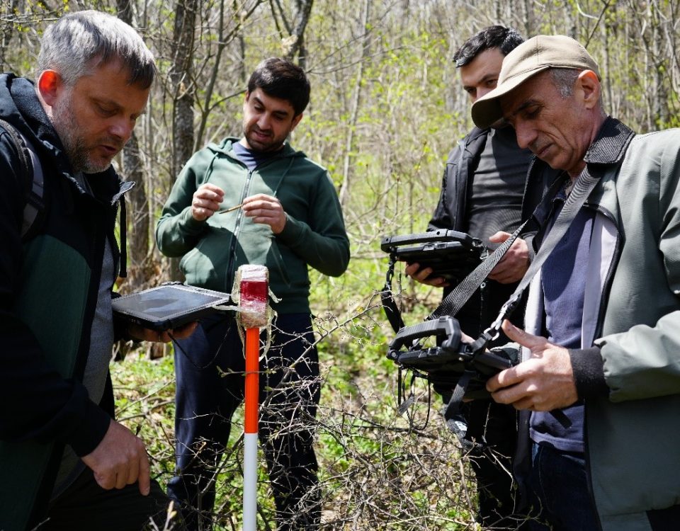
Arena Mobile supports national forest inventories, biodiversity assessments and socio-economic surveys. As the mobile companion to Arena, it enables offline field data collection in remote areas, capturing field data, GPS locations, images, audio, video and text with built-in validation rules. Once connectivity is restored, data synchronises with the Arena platform for processing, monitoring and reporting.
In 2025, Arena reached 3 883 registered users across 110 countries, with more than 4 400 Arena Mobile installations. Developed by FAO with support from the UK-funded AIM4Forests programme, Arena and Arena Mobile are widely used in long-term national forest monitoring systems. Impact stories from Kosovo, Mexico and Mongolia demonstrate how capacity development supports sustained national use beyond individual projects. An annual Open Foris Arena User Meeting provides a key forum for knowledge exchange and community-driven development.
Ground
Ground is a map-first, user-friendly field data application designed for non-technical users such as community groups, smallholders and Indigenous Peoples. By the end of 2025, Ground recorded over 4 000 unique logins and more than 1 600 Android installations, alongside growing uptake through self-paced e-learning available in multiple languages.
Jointly developed by FAO and Google and funded through AIM4Commodities, with GIZ and UK support as part of AIM4Forests programme, Ground plays a key role in deforestation-free supply chains, and increasingly for restoration monitoring Integration with Whisp allows field data to automatically trigger deforestation risk assessment, while links with FERM support field verification of restoration projects.
A major milestone in 2025 was the launch of self-paced e-learning for Ground in collaboration with the FAO elearning Academy.
Visual interpretation
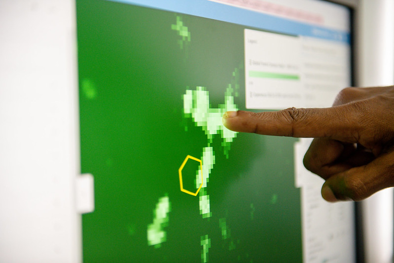
Collect Earth Online
Collect Earth Online (CEO) is a web-based platform for collaborative visual interpretation of high-resolution satellite imagery. Up to 2025, CEO supported the interpretation of over 5.3 million samples, with around 16 000 active users.
Developed by FAO in collaboration with the Spatial Informatics Group (SIG), CEO is widely used for sample based assessment to support measurement, reporting and verification (MRV), land-cover change mapping and standardized interpretation campaigns at national and regional scales.
Collect Earth
Collect Earth is a free, open-source desktop solution that enables detailed land-use and land-cover analysis through visual interpretation of high-resolution satellite imagery. Leveraging Google Earth Pro and Google Earth Engine, Collect Earth has supported the collection of approximately 700 000 plots since its inception. Collect Earth supports time-series analysis, change detection and map accuracy assessment for applications such as national forest inventories, MRV and greenhouse gas estimation. Integrated with Open Foris Collect, it allows countries to design flexible, validated surveys and export analysis-ready data for national reporting and decision-making.
Data management
Collect
Collect is a desktop solution for designing complex surveys with validation rules for managing forest inventory data. It supports national forest inventory workflows and integrates seamlessly with Collect Earth for combined field and visual interpretation approaches. Open Foris Collect is a stable, dependable tool that will continue to get maintenance and bug fixes. For new surveys (except Collect Earth), advanced design, data management, and analysis, Arena is recommended.
Arena
Arena is a modern cloud-based platform for designing, managing and analysing field inventories, socio-economic surveys and other environmental data. It enables users to customise survey structures, manage multilingual projects, conduct quality control and collaborate in real time through secure cloud storage. Arena supports integration with geospatial imagery, advanced analysis through RStudio and the export of results into standard formats, making it well suited for national forest inventories, multi-cycle surveys and climate reporting workflows.
Geospatial analysis
SEPAL
The System for Earth Observation Data Access, Processing and Analysis for Land Monitoring (SEPAL) provides cloud computing and direct access to global satellite data. SEPAL supports nearly 20 000 users across 196 countries, enabling National Forest Monitoring Systems, MRV, deforestation alerts and climate reporting.
In 2025, SEPAL expanded its AI-powered capabilities, integrating multiple global forest monitoring systems and machine-learning approaches for deforestation risk modelling. SEPAL is funded through NICFI and supports global initiatives such as the Tropical Forest Forever Facility (TFFF).
Earth Map
Earth Map is a web-based geospatial platform to visualise, analyse and share land and forest monitoring data, democratizing geospatial and climate data through a point-and-click interface. Country deployments in Guatemala, Benin and Guinea support land-use planning, restoration prioritization and reporting. Funded through AIM4Forests, Earth Map is increasingly integrated with SEPAL, reducing technical barriers for country teams.
Integrated solutions and risk assessment
Whisp
Whisp is an open-source solution that applies a convergence-of-evidence approach to assess deforestation risk. In late 2025, Whisp recorded 250 active API keys and 4 300 API calls in December only.
Developed by FAO and funded through AIM4Commodities, Whisp supports due diligence and compliance workflows for deforestation free supply-chain actors and regulators, integrating national datasets where available.
Framework for Ecosystem Restoration Monitoring
The Framework for Ecosystem Restoration Monitoring (FERM) is a global platform supporting restoration tracking under the UN Decade on Ecosystem Restoration and GBF Target 2. With the support from the AIM4NatuRe initiative, funded by the United Kingdom as part of the AIM4Forests programme, FERM hosts over 800 restoration projects across 142 countries, with nearly 2 000 registered users. Integration with Ground enables field-level verification of restoration progress.
Why Open Foris matters
Open Foris supports transparent, reliable and inclusive forest and land-use monitoring. Around 90 percent of forest-related country submissions to the UNFCCC have used Open Foris solutions. By lowering technical barriers while strengthening country ownership of data, it helps turn high-quality information into action for forests, people and the climate.
A key strength of Open Foris are the synergies across platforms, which increasingly function as an interoperable ecosystem. For instance, Arena can call Earth Map to visualize sample plots on a map, from where users can apply Earth Map’s analysis features, while SEPAL and Earth Map provide streamlined access to satellite data, analytics and national reporting workflows and visualization.
Looking ahead to 2026, Open Foris will further enhance interoperability, usability and performance with greater use of automation and AI assisted workflows. Planned activities include expanded capacity development, including new Arena micro-learning resources through FAO’s eLearning Academy and deeper integration across FAO programmes and partner initiatives.
The AIM4Forests programme will also focus on supporting the uptake of Open Foris solutions among Indigenous Peoples and forest community organizations. This includes tailoring and field-testing Open Foris solutions with local users, delivering targeted training, including on Ground for restoration and commodity-related farm-level plot mapping, as well as on SEPAL for MRV activities under the Indigenous Jurisdictional REDD+ programme in Peru, and collaborating with government to integrate locally generated data into national forest monitoring and reporting processes.
- Open Foris – Open Foris unites communities and practitioners with open-source tools, making forest and land monitoring accessible, transparent, and collaborative for people and the planet
- Impact stories – Open Foris
- Open Foris In Action
- SEPAL In Action
- Harnessing technology and innovation to transform our forests | FAO
- Artificial intelligence in forest monitoring: uses, applications, adoption and precautions
This article was originally published here.